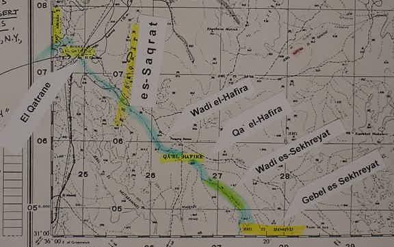
Map of the Zered, "river of, valley of"
(De 2:13-14; Nu 21:12; 33:44-45)
10 March 2004 Revision & Update
The "Brook" of Zered (Massoretic Texts) or "Valley" of Zared/Zered (King James Version)," (Greek Septuaginta and Latin Vulgate Texts) LXX : Zerat, Zerad.
Most scholars understand that Wadi el Hesa between Moab and Edom is the Zered. The problem? Ije-Abarim (King James Version) or Iye-Abarim (Revised Standard Version) is described in the texts as being reached BEFORE the Zered.
The texts are also quite explicit that Ije-Abarim or Iye-Abarim is EAST OF MOAB _NOT_EDOM. By making the Zered Wadi el Hesa, scholars have made Ije-Abarim east of Edom!
Herion on the Zered being Wadi el Hesa and the border between Moab and Edom :
"Thus, most scholars identify the Zered with the Wadi Hesa, which empties into the Arabah Valley near the SE end of the Dead Sea, and consider its 35-mile-long canyon-with its span of 3.5 to 4 miles- to have been the ancient boundary between Moab and Edom." (p. 1082. Vol. 6. Gary A. Herion. "Zered, Brook of." David Noel Freedman. Editor. The Anchor Bible Dictionary. 1992. Doubleday-Anchor. New York. 6 volumes)
Nu 33:44-45 (RSV)
"And they set out from Oboth, and encamped at Iye-Abarim, in the territory of Moab.And they set out from Iyim, and encamped at Dibon-Gad."
Nu 21:12 (RSV)
"And they set out from Oboth, and encamped at Iye-Abarim, in the wilderness which is opposite Moab, toward the sunrise. From there they set out, and encamped in the Valley of Zered."
Nu 21: 11-12 (Septuaginta. [1851 English translation by Sir Lancelot Brenton])
"And having departed from Oboth, they encamped in Achalgai, on the farther side of the wilderness, which is opposite Moab, toward the east. And thence they departed, and encamped in the valley of Zared."
I understand that Zered, pronounced Zeh`red is preserved as es-Saqrat, a height or elevation to the east of the "way of the wilderness to Moab." Could the Arabic "q" be an attempt to preserve the Hebrew aspiration, Zeh`red ? This track parallels the es-Saqrat heights. The track actually lies in a depression, valley, defile or pass, formed by the heights of es-Saqrat on the east and Gebel Subeban on the west and on the below map this track is seen going north as a dark line from El Qatrane which I suspect preserves the word Arnon. The "brook of Zeh`rat, Zeh`red, I understand to be Wadi el Hafire draining from Qa `El Hafire. Wadi es-Sekhreyat draining from Gebel es-Sekhreyat is a principal headwater of Wadi el Hafire. I understand that the "brook" of Zered either takes its name from the defile-valley pass of es-Saqrat which it crosses, or from its headwater, Wadi es-Sekhreyat (Azraq Map. South Levant. 1:250,000. Sheet NH 37 A. U.S. Army Map Service. 1946). This map was made to accompany my article titled "The Route of the Exodus."
