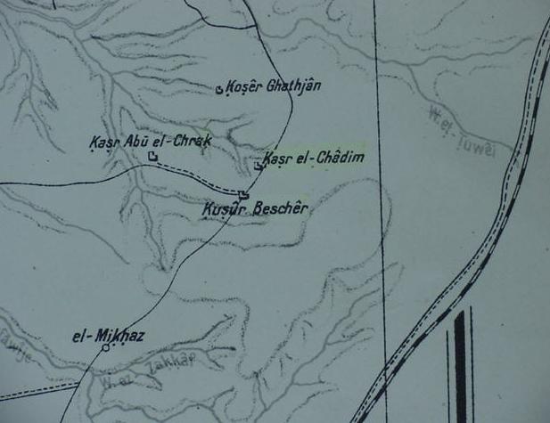
Map of the wilderness of Kedemoth (De 2:26)
10 March 2004 (Revisions through 08 May 2010)
The Wilderness of Kedemoth (De 2:26). Moses sends messengers from the "wilderness of Kedemoth" to Sihon the Amorite, asking permission to cross his lands. This is denied and Sihon engages Israel at Jahaz /Jahazah (De 2:32). Kedemoth appears as a town for the tribe of Reuben (Josh 13:18) "...Jahaz and Kedemoth and Mephaath..."
Peterson noted there is no consenus amongst scholars for Kedemoth's location:
"There is not universal agreement regarding the location of biblical Kedemoth and the geogragphers give their suggestions tentatively. Kedemoth is a town situated N of the Arnon. It is probably an outpost toward the desert. It is impossible to define its location more precisely." (p.10 Vol. 4. John L. Peterson. "Kedemoth." David Noel Freedman. Editor. The Anchor Bible Dictionary. New York. Doubleday. 1992)
I suspect that Kedemoth is Qasr el Khadim, a site just west of the "way of the wilderness to Moab" which Israel was traveling enroute to Moab from Ezion Geber, Elath and the Gulf of Aqabah. Musil lists the site as Kasr Khadem (Alois Musil. Karte von Arabia Petraea. 1:300,000. Vienna. 1907), while a Geman map made in 1918, lists the site as Kasr el-Chadim (Bearabeit in der Kartogr. Abteilung der Kgl. Preuss. Landes. Aufnahme. April 1918, which appears "below" on this page). That is to say I understand that "the wilderness" _of_ Kedemoth is the wilderness _east_ of Kasr Khadem through which passes the "way to the Wilderness of Moab" taken by Israel.
It appears to me that biblical scholars (1907-2010) are "unaware of" just how important Alois Musil's map made in 1907 is, for it shows a site called Kasr Hadem (the diacritical under the H revealing it is pronounced Khadem, alternately Qasr Khadem) as the easternmost outpost of the area called in the Bible Sihon's Amorite kingdom. Had these scholars carefully studied Musil's map there would be no more wondering and confusion about where "the wilderness of Kedemoth" is!
As revealed on the below 1918 map, Kasr el Chadim is indeed "an outpost" overlooking the wilderness. The Arnon's eastern-most tributary does drain from the high tableland which Kasr el-Khadim sits atop (note the Arabic word Khirbet, meaning an abandoned site, is rendered as an abbreviation on the 1918 map as Ch. , for example between Arad and Hebron are the following khirbets : Ch. el-Karjaten, Ch. el-Fecht, Ch. u. Tell Ma`in, Ch. Ghanaim, etc.).
I understand that the "Wilderness of Kedemoth" is the wilderness to the east of Qasr el Khadem, through which passes the track called in the Bible, "the way of the wilderness to Moab." The 1918 map shows this track as a line with dots, which is paralleled by a railway. I thus understand Israel camped near the "Way of the wilderness to Moab" just east of el-Khadem, and south of Wadi et-Tuwei.
Perhaps biblical Bezer (Hebrew Beser with a diacritical dot under the "s") is Kusur Bescher (Musil's Ksur Bsejr), adjacent to and south of Kasr el Chadem on the 1918 map? Both sites lie on a high tableland. There is no consensus amongst scholars on Bezer's location.
Mattingly:
"Although its exact location is unknown, Bezer is often identified with Umm el-`Amad, which is located ca. eight miles northeast of Medeba." (p.719. Vol. 1. Gerald L. Mattingly. "Bezer." David Noel Freedman. Editor. The Anchor Bible Dictionary. New York. Doubleday. 1992)
De 4:43 RSV
"Bezer in the wilderness on the tableland for the Reubenites..."
Josh 20:8, RSV
"And beyond the Jordan east of Jericho, they appointed Bezer in the wilderness on the tableland, from the tribe of Reuben..."
